You are here

Viet Nam Tackles Soil Erosion With Nuclear Techniques

,
Dao Thanh Canh

Thanks to nuclear techniques, farmer Dao Thanh Canh was able to control soil erosion on his coffee plantation. (Photo: P. S. Hai/Centre for Environmental Research and Monitoring, Dalat Nuclear Research Institute)

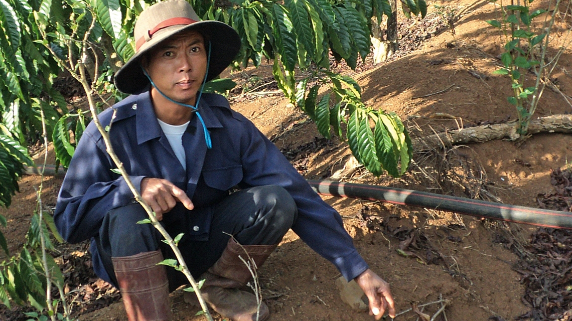
Dao Thanh Canh never studied physics or chemistry in school, but he understands a thing or two about nuclear isotopes. Until a couple of years ago, much of his five-acre farm on the hills of central Viet Nam was gradually sliding away. Thanks to nuclear techniques used in determining the exact cause and source of soil erosion, his land is now stable, and his coffee plantation profitable. "We were very worried as uncertainty loomed," he said. "A few centimetres of the soil disappeared every year when we had big hail storms."

Thanh Canh is not alone. Soil degradation affects 1.9 billion hectares of land worldwide, close to two thirds of global soil resources.

Soil erosion is the main contributor to land degradation globally, leading to an annual loss of 75 billion tonnes of fertile soil, with an economic cost of about US $126 billion per year. The IAEA, in partnership with the Food and Agriculture Organization of the United Nations (FAO), helps scientists and farmers in measuring and controlling soil erosion through the use of various nuclear techniques. These include using fallout radionuclides, which help to assess soil erosion rates, and compound specific stable isotope analysis, which assists in tracing hot spots of land degradation (see Fallout radionuclides and compound specific stable isotope analysis).

Erosion's vicious cycle

Erosion affects the top — most fertile — layer of the soil. It also carries away much of the fertilizer used in agriculture and deposits it in fresh water, where the fertilizer feeds algae, which sharply decrease water quality. "It is a double blow," said Mohammad Zaman, a soil scientist at the Joint FAO/IAEA Division of Nuclear Techniques in Food and Agriculture.

Now that we know where precisely erosion comes from, we can undertake the proper mitigation measures.
Othman Zainudin, Sultan Idris University, Tanjong Malim, Malaysia

The sloping hills of Viet Nam are particularly susceptible to soil erosion. (Photo: P. S. Hai/Centre for Environmental Research and Monitoring, Dalat Nuclear Research Institute)

Intensive agriculture, along with deforestation, is a common cause of erosion, Zaman explained. Aggressive farming removes the organic matter that binds the soil particles together, leaving the area vulnerable to erosion during heavy storms. Nuclear techniques help identify erosion hot spots, enabling follow-up mitigation measures to focus on areas most at risk. "As a result of our work, treatment is more targeted, more effective and as a result cheaper," Zaman said. Following the impact of the project in various Asian countries, the IAEA is now working to replicate its success in other parts of the world and is forming a network of national experts to share best practices and know-how.     

Measuring erosion to find solutions

In Viet Nam, where three quarters of the country's territory is sloping land, erosion is a major problem. An FAO/IAEA pilot project in Lam Dong province in Viet Nam measured soil erosion rates using nuclear techniques at 27 sites. Adopting appropriate conservation practices such as intercropping, creating basins near coffee trees to trap water, and building terraces, led to a 45 per cent reduction in soil erosion, said Phan Son Hai, Director of the Centre for Environmental Research and Monitoring at the Dalat Nuclear Research Institute, which has participated in the project since 2012. Similar results were achieved throughout the region (see Chart). Son Hai is now assisting colleagues across the country to introduce nuclear techniques for erosion monitoring nationwide.

Reduction in soil erosion in target areas since 2012. (Source: IAEA)

In Malaysia, which is also part of the project, Othman Zainudin has been monitoring an area of high erosion in Perlis State, in the northern part of the country, for over ten years, and switched to using nuclear techniques two years ago. "With the new techniques we can obtain much more detailed information," said Zainudin, who teaches geomorphology at the Sultan Idris Education University in northern Malaysia. Previously, his team could only measure sedimentation rates in lakes, but could not identify the exact source of the sediments, he explained.

"Now that we know where precisely erosion comes from, we can undertake proper mitigation measures," Zainudin said. Later this year, in cooperation with the State Agriculture Department, he will organize a training programme for farmers on techniques to reduce soil erosion. "We could not have done such a knowledge transfer programme before because we did not know the precise source of erosion," he said.

As for Dao Thanh Canh in Viet Nam, his income has increased by over 20 per cent, with tea plants and animal fodder growing in erosion hot spots among his coffee trees. He is no longer uncertain about the future and feels free to spend his extra income, he said. Much of his extra money is now going toward schooling for his four children. "I am determined to offer them the education I could never get," he said.

Stay in touch

Newsletter