You are here

Combatting Soil Erosion to Help Achieve Zero Hunger and Clean Water: IAEA Commemorates World Soil Day

,

Isotopes were used to determine soil erosion rates of experimental plots with no-tillage (front) and conventional tillage (back) land management in Zimbabwe. (Photo: E. Fulajtar/IAEA)

Over 45 billion tons of soil are lost to erosion every year. Farmers and agricultural authorities in several countries have succeeded in slowing down erosion with the help of nuclear techniques. Here are their stories from Zimbabwe, Argentina and Sri Lanka. 

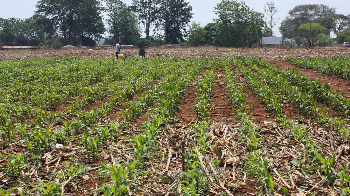
All over the world, the Earth’s fine soil particles are losing ground to erosion. As 95 percent of food is cultivated in soil, the health and availability of Earth’s living surface impacts the quality and quantity of the food we produce. “Agricultural landscapes lose valuable soil mainly through soil redistribution processes,” said Emmanuel Chikwari, Head of the Chemistry and Soil Research Institute in Zimbabwe. “Once the soil resource is lost, it cannot be replaced for generations.”

While wind and rain will always cause some erosion, this is amplified by improper agricultural practices, overgrazing, deforestation and climate change. Each year, approximately 45 billion tons of soil are displaced from agricultural use, and land is abandoned due to deteriorating productivity caused by erosion. The topic of this year’s World Soil Day is soil erosion — a process that nuclear techniques can help track and mitigate.

Healthy soils play an important role in achieving the United Nations Sustainable Development Goals — on hunger, clean water and the protection of the terrestrial environment. By applying nuclear techniques to measure and monitor the impact of land use and subsequently identify strategies to mitigate erosion, the IAEA, in cooperation with the Food and Agriculture Organization of the United Nations (FAO), is working to help conserve this vital resource.

What is soil erosion?

Soil erosion, the most common type of land degradation, is a natural process that displaces the upper layer of soil, which is where plants get most of their nutrients and water needed for growing. Erosion is accelerated by human activities, such as removing the natural vegetation that protects the lands’ surface and converting it to cultivated and pasturelands. Soil erosion is particularly damaging for countries in tropical, subtropical and arid climate zones. It is most prevalent in Africa, affecting 65 percent of cropland, followed by Latin America with 51 percent and Asia with 38 percent.

The impact of soil erosion runs far beyond food production. “Soil erosion significantly reduces cropland productivity and contributes to the pollution of watercourses, wetlands and lakes,” said Hugo Velasco, Professor at the Physics Department of San Luis National University and Independent Researcher at the National Research Council of Argentina (CONICET).

As soil disperses via waterways, sediments accumulate in reservoirs, diminishing their capacity and harming aquatic ecosystems and biodiversity. “This natural process becomes even more critical in arid and semi-arid zones due to two main reasons: agricultural areas were expanded at the expense of native forest cover, which disturbs the hydrological balance, and precipitation trends have increased with a higher frequency of extreme rainfall events,” Velasco explained.

In the last decades, nuclear techniques utilizing X-rays and environmental radionuclides, typically fallout radionuclides (FRNs) as tracers, were introduced to assess erosion rates and to identify the origin of the displaced sediments.

FRNs are naturally occurring or man-made radionuclides released into the atmosphere and deposited on the ground by rainfall in trace amounts. They strongly bind to soil particles, and the soil’s FRN concentration can be used to estimate soil erosion. If the FRN content of a studied area is lower than the amount found in an undisturbed, reference area, it means soil at the studied site has been lost to erosion.

Since 1995, experts in more than 70 countries have benefitted from support by the IAEA and the FAO in the use of nuclear techniques related to soil health and management.

Zimbabwe: Isotopes guide effective soil conservation practices

With an average of 450 to 600 mm of rain per year, large parts of Zimbabwe are semi-arid and experience limited water supply due to drought. This contributes to the challenges facing the agricultural sector, which plays a major role in its economy, employing about 67 percent of the workforce and comprising 45 percent of exports.

Year after year, “the consequences of erosion are seen in declining crop yields and high rates of siltation of reservoirs, especially of the smaller dams used for rural water supplies,” Chikwari said. The severity of land degradation led scientists to estimate that the cultivation of crops, such as maize, will only be possible for another 15 years before soils become too poor to support farming, and many small dams are likely to fill with sediments. Various soil conservation measures need to be implemented, but until recently it has not been clear how, Chikwari added. “Previous efforts to obtain information were based on direct measurements of soil losses, which required a lot of labour and capital investment.”

To quantify the effectiveness of various soil conservation strategies, the Chemistry and Soil Research Institute in Zimbabwe launched a study utilizing caesium-137 (Cs-137) isotopes. In the 1950s and 1960s, Cs-137 radionuclides were released into the atmosphere by nuclear weapon tests and deposited in soils worldwide. By measuring Cs-137 concentrations, scientists could estimate soil erosion rates, specifically to compare the erosion of plots with and without tillage.

Soil erosion rates under conventional tillage reached 6.2 ton per hectare per year (t/ha/y), while rates were nearly 55 percent lower at no-tillage plots, at only 2.8 t/ha/y. “With the results of the study, we have the knowledge to improve our soil conservation efforts, and in turn, increase food security,” Chikwari said.

Argentina: X-rays reveal the source of sediments deposited in water reservoirs

Small water reservoirs, such as La Estrechura pictured, in Argentina are severely endangered by sedimentation, which reduced their volume and water storage capacity. (H. Velasco/CONICET)

Loose sediments from an erosion site can affect surrounding ecosystems. In the semi-arid region of central Argentina, sediments have contaminated the Volcán river, threatening water resources and clogging the region’s main dam by more than 60 percent. “The Cruz de Piedra dam lost its storage capacity, and signs of eutrophication have become evident,” Velasco said.

The IAEA through its technical cooperation programme, in cooperation with the FAO and in partnership with the Environmental Studies Group of the San Luis Institute of Applied Mathematics, sought to determine the nature and location of the main sources of sediments transported by the river with X-ray fluorescence (XRF) technology. When soil elements are exposed to X-ray beams, small quantities of energy are emitted and detected by an XRF spectrometer. “These concentrations of energy are mainly conditioned by the type of soils, the geological substratum from which they originate and the land uses,” Velasco said.

Approximately 80 surface soil samples from 20 to 30 recognized sources of sediments surrounding the Volcán river and from 10 deposit sites in the river were collected. Though cultivated land occupied most of the studied area, it only contributed between 6 to 16 percent of the overall sediment composition. The XRF results showed that the major source of sediments is the removal of soil by concentrated water running through little streamlets along unpaved roads, followed by river bank erosion. Scientists concluded that soil conservation measures were not necessary on cultivated lands, so efforts should focus on maintaining roads and river banks in the upper part of the watershed to minimize erosion.

Sri Lanka: Fallout radionuclides guide conservation practices, leading to a 42 percent reduction of soil losses

In Sri Lanka, terraced fields and gardens comprise the Central Highlands, producing tea, rubber, spices and vegetables. These fields contribute 20 percent of Sri Lanka’s GDP; however, this area is highly prone to soil erosion, which at one point reached almost 40 t/ha/yr of soil loss. The soil conservation programme requires reliable and representative data on soil erosion rates, spatial distribution and efficiency of conservation measures.

The IAEA through its technical cooperation programme, in cooperation with FAO and in collaboration with the Sri Lanka Atomic Energy Board and Natural Resources Management Centre, carried out the measurement of Cs-137 radionuclides to pinpoint areas for conservation activities to improve soil management.

By analysing the amount of Cs-137 concentration at different sites, scientists were able to identify specific locations for the deployment of conservation measures. Changing the shape and orientation of fields, planting vegetation under tea plants to stop soil from moving, creating stone barriers to hinder water runoff and planting leguminous trees significantly reduced soil losses. It was estimated that soil conservation activities in Central Highland tea plantations minimized annual soil erosion by 42 percent (from almost 40 t/ha/yr to 23 t/ha/yr).

Scientists in Sri Lanka used fallout radionuclides to identify specific locations for the deployment of conservation measures, which included changing the shape and orientation of fields. (Photo: Sri Lanka Atomic Energy Board)

Stay in touch

Newsletter