• English
  • العربية
  • 中文
  • Français
  • Русский
  • Español

You are here

Bridging the Gap between Science and Policy: IAEA Provides the Necessary Tools to Climate Change Researchers

,
,

Training course participants hike to the Pasterze glacier in the Austrian Alps, passing here the glacier position of 2015. (Photo: IAEA)

Twelve international students have honed their skills in sampling and data interpretation at a two-week training course, part of an interregional IAEA technical cooperation (TC) project[1], performed in close cooperation with the Food and Agriculture Organization of the United Nations (FAO), to assess the impacts of climate change on land-water-ecosystem interactions.

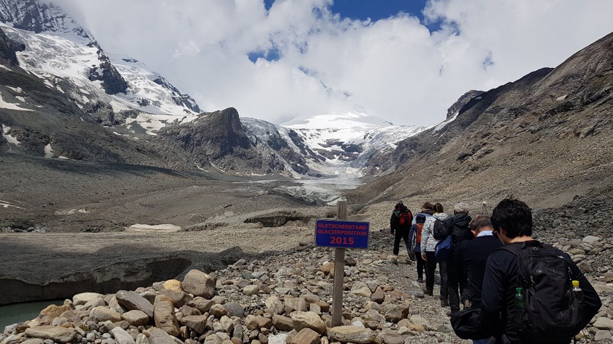
The project focuses on polar and mountainous regions where the impacts of climate change are known to be more pronounced and to occur more rapidly, and specifically on the use of isotopic and nuclear techniques. The goal is to help Member States to better and sustainably conserve and manage their natural resources.

The training course, held from 25 June to 8 July 2018, was hosted by the University of Vienna’s Department of Microbiology and Ecosystem Science, the Department of Geography and Regional Science at Graz University and the Joint FAO/IAEA Division of Nuclear Techniques in Food and Agriculture. The course aimed to provide the 12 participants with a range of tools for sampling and interpreting data to enable subsequent assessment of the impacts of climate change on soil organic carbon, sediment redistribution and glacier dynamics in mountainous and polar environments.

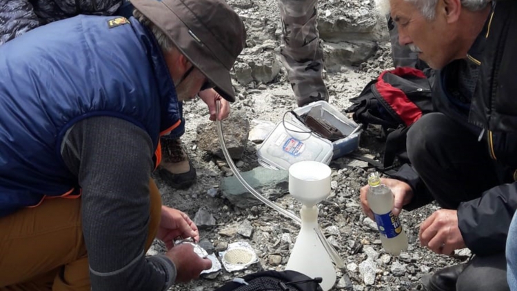
At the FAO/IAEA’s Soil and Water Management & Crop Nutrition Laboratory in Seibersdorf, Austria, participants attended lectures and participated in exercises on the development of research questions and protocols, and on data interpretation for assessing climate change impacts on high-mountain land-water-ecosystem interactions. Breakout groups focused in greater detail on assessing the impact of climate change on soil organic carbon fluxes, sediment reallocation and cryosphere dynamics.

The participants undertook a four-day field excursion to Rauris, the project’s benchmark site in the Austrian Alps, as part of the course. Here they received hands-on training in sampling and measurement protocols to evaluate the impacts of climate change on land-water-ecosystem quality in mountainous and polar regions.

Participants now have the capacity to establish long term monitoring for analysing climate change impact, consistent with methods used in other benchmark sites around the world, as well as having the ability to interpret the resulting data in a meaningful way for policy makers.
Najat Mokhtar, Director, Division for Asia and the Pacific, IAEA Department of Technical Cooperation

Taking water samples from a proglacial stream to determine the sediment concentration (Photo: IAEA)

“Through the field excursion the participants learned to appreciate the principles and practical implications of sampling and measurement protocols to assess the impact of climate change on land-water-ecosystem quality in mountainous and polar regions,” said Gerd Dercon, Head of the Soil and Water Management and Crop Nutrition Laboratory at the Joint FAO/IAEA Division.

These methods, which include isotopic fingerprinting, were adapted and refined during seven earlier expeditions to benchmark sites in Patagonia, Chile; King George Island, Antarctica; Svalbard, Norway; Mount Gongga, China; Caraz, Peru; Elbrus, Russian Federation and Huayna-Potosí, Plurinational State of Bolivia.

This hands-on training will allow participants to set up long-term benchmark sites in other regions. A visit to the 40 km2 Pasterze watershed, containing the largest glacier in the Austrian Alps, enabled the demonstration of various field techniques, including the use of fallout radionuclides in combination with complementary geochemical fingerprints for sediment tracing, the use of carbon-13 and nitrogen-15 to assess organic matter origins, a ground survey of selected glacier and snow cover properties (water sampling, ice sampling, temperature measurements, conductivity measurements and analysis of water properties), and the use of carbon-14 to determine the age and stability of carbon.

“Often methods to collect data are not comparable to other parts of the world. By using techniques and methodologies taught in this course, our assessments can be compared to results from other benchmark sites around the world”, said participant Ksenia Poleshchuk from the Arctic and Antarctic Research Institute (AARI) in the Russian Federation.

Filtering water sediment in the field to determine river sediment load (Photo: IAEA)

Science for everyday life

Participants also interacted with farmers and interest groups from the Rauris area affected by the impacts of climate change. Local farmers, the mayor of the municipality of Rauris and the director of the Sonnblick meteorological observatory gave participants an insight into the local socioeconomic context of climate change impacts.

Participant Anna Oaquim from the Universidade do Estado do Rio de Janeiro in Brazil welcomed this opportunity. “This allows us to do science not just for the sake of it, but rather to see the results of our applied research through practical results in everyday life by those directly affected by climate change,” she said. Sabur Abdullaev from the PhysicoTechnical Institute of the Academy of Sciences in Tajikistan added: “This provided us with the opportunity to witness the importance of demystifying nuclear techniques to the general public - which is the first to benefit from nuclear techniques applied to assessing the impacts of climate change.”

The training course also provided participants with an opportunity to exchange experiences and knowledge among themselves. Renan Cardoso, Universidade Federal Fluminense (UFF), Brazil, said: “The network established through this meeting can help to connect the methodological and analytical capacity in Brazil to cryosphere locations in other Latin American countries.”

The way forward

On returning to their countries, participants are expected to apply their newly acquired knowledge to establish long-term monitoring mechanisms for analysing climate change impacts on land-water-ecosystem interactions in high-mountainous areas, as well as to interpret the resulting data in a meaningful way for policy makers, thus supporting the implementation of evidence-based decisions and policies. Guozheng Hu, Institute of Environment and Sustainable Development Agriculture in China, agreed, saying: “This training will assist me in disseminating methodological and multi-disciplinary approaches to other countries in the Himalaya region.” Marcelo Gorritty, Instituto de Investigacion y Desarrollo de Procesos Quimicios (IIDEPROQ), Bolivia, added: “We must use two levels of dissemination: first through universities to students and researchers, second to authorities and public institutions. The latter requires a translation of the knowledge into a big picture view, and improved communication with university and authorities.”

Innovative methods for dissemination were discussed during the closing meeting: “New technologies such as virtual reality could be used to show Antarctica and the impact of climate change to the youth,” said Renan Cardoso.

Jane Gerardo-Abaya, Section Head, Division for Asia and the Pacific, IAEA Department of Technical Cooperation, congratulated successful participants. “Increased understanding of the impacts of climate change in these fragile high-altitude and high-latitude areas is greatly required,” she pointed out. “The establishment of benchmark sites, not least in the southern hemisphere, is therefore imperative to develop meaningful strategies to help manage the environment. Your newly acquired knowledge here has importance to help protect the ecosystem services provided by mountainous areas, as well as the communities living in these fragile environments.”

“Participants now have the capacity to establish long term monitoring for analysing climate change impact, consistent with methods used in other benchmark sites around the world, as well as having the ability to interpret the resulting data in a meaningful way for policy makers,” said Najat Mokhtar, Director, Division for Asia and the Pacific, IAEA Department of Technical Cooperation, summing up the achievements of the course.

The impact of the course will be evaluated at the end of 2018 to examine how the participants are applying the training and knowledge acquired during the project.

Learning to identify proglacial features such as moraines, which indicate previous fronts of the glacier (Photo: IAEA)

[1] INT/5/153, "Assessing the Impact of Climate Change and its Effects on Soil and Water Resources in Polar and Mountainous Regions".

Stay in touch

Newsletter