
A thorough analysis of data is vital to a swift response in a radiation or nuclear emergency. The new international radiation monitoring information system (IRMIS), recently launched by the IAEA, collects and displays radiation monitoring data, enabling countries to respond rapidly to such emergencies. This data maps the areas of potential impact that can assist countries to take appropriate protective actions in an emergency.
By sharing information Member States are better prepared for challenging situations, said Jan Erik Dyve, a radiation specialist with the Norwegian Radiation Protection Authority.
This new web online tool supports the IAEA's Unified System for Information Exchange in Incidents and Emergencies (USIE), an online tool where competent authorities can access information about all emergency situations, ranging from a lost radioactive source to a full-scale nuclear emergency.
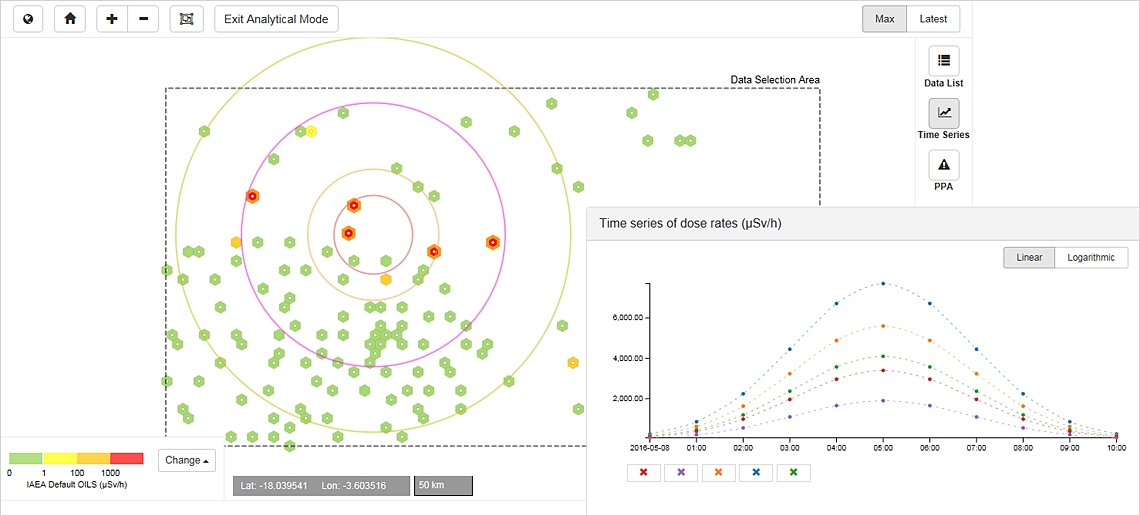
One of the main sources of such information is gamma dose rate data, which is voluntarily reported from fixed monitoring stations worldwide, said Elena Buglova, Head of the IAEA Incident and Emergency Centre. "The data received is integrated with geographic coordinates and then visualised on a map."
IRMIS provides a mechanism for reporting these specific measurements from the fixed monitoring stations worldwide. At the same time, the system is also capable of accepting emergency gamma dose rate data collected through temporary stations, hand-held measurements or mobile monitoring systems, such as backpack systems, vehicle or aerial systems. This allows the data to be mapped, visualised and assessed against the area where focussed protective actions, such as evacuation, sheltering and food restrictions, can be taken.
When and where to take action
The online system has specifically pre-designed colour coded palettes that can differentiate displayed radiation levels. It allows for the evaluation of radiation measurement trends over a selected time period and the display of near real time results at a given location.
IRMIS is not an early warning system that automatically reports when there are significant deviations in radiation levels or when values are detected above certain levels, Buglova said. However, the configuration of the visualization features offered by IRMIS may help Member States to determine where elevated gamma dose rate measurements during a radiation of nuclear emergency indicate that actions to protect the public are necessary.
"The data can be used to assist emergency responders determine where and when to take necessary actions to protect the public," she said.
IRMIS supports the implementation of the Convention on Early Notification of a Nuclear Accident whereby the Signatory Parties have a mechanism for reporting environmental radiation monitoring data during nuclear or radiological emergencies. Future versions of IRMIS will also enable the reporting of radioactivity measurements of environmental samples collected during an emergency, said Buglova.
Member States' authorities and technical organizations with a national role in collecting and reporting radiation monitoring data are encouraged to voluntarily provide data to the online system. IRMIS is currently launched for all users of the USIE system and future developments including public accessibility are foreseen to be implemented over the next couple of years.

